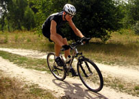


MOUNTAIN BIKING TRAILS![]()
Sticks & Stones, NORTH CONWAY (1.5M of groomed single track with optional features) Artists Falls Rd. to Thompson Rd. From parking lot, 1/4m sandy access road to Pudding Pond kiosk. Single track trail on right side of sign. Go either way at fork. Trail easily followed on 1.5M sinuous, roller coaster loop. New sections of single track on right side.
Red TAIL trail, KEARSARGE (3-4M steep technical single track) From base of Hurricane Mt.Rd., approx. 1/2M up on right look for pull off. Park and cross log bridge to grassy clearing. Ride uphill to the left for about 2.5M to intersection with Cranmore Trail. Ride downhill to the right traversing Kearsarge Brook for about 3/4M. Exit at water tank.
The Presidential Range Rail-trail, GORHAM-RANDOLPH (4.5M 1 way, gentle grade, smooth, double track round trip 9m 2 hrs.) Trail follows old railway that parallels Rt. 2, Gorham to Lancaster. Rails & ties removed, for wide path through scenic country. Start in Gorham at parking lot about 1/2M west of traffic light on Rt. 2. Climb gently along Moose River 4.5M until Pinkham B Rd. Cross river 3 times on old RR bridges retrofitted to accommodate recreational use. Ride west past Pinkham B Rd., along Rt. 2, as far as you want or turn around, you’ll have a pleasant, scenic downhill back.
Franconia, Lincoln & Woodstock year-round multi-use trail starts at Echo Lake beach. Ride south on maintained trails (Corridor 11), shuttle takes you back through scenic notch to wherever you left your car.
ROAD BIKING ROUTES![]()
Jackson Village Loop (6.5 miles • Moderate hills. Spectacular scenery.) Start at Wentworth Inn, ride up hill past Jackson Falls. Continue past Eagle Mountain House. About 1M turn right over Wildcat River. Ride up gradual hill about 1.5M to Whitney’s Inn. Turn right at stop sign, climb short hill, then begin long, sometimes steep descent back to Jackson.
Wonalancet Loop Tamworth (22 miles - moderate hills) From Brett School, Rt 113 ride to Rt 25. Turn right, ride 3M on Rt. 25 to Bennett’s Corner. Go right on Rt 113, ride 4M to N. Sandwich. Turn right at Sandwich Store. Continue north Rt 113A, into Whiteface - it crosses Cold River, bear right & enter Wonalancet Intervale about 6M. Go right at white church. Pass Chinook Kennels, begin long downhill back to Tamworth Village, about 5M. Go straight at four corners, 2M back to the school.
West Side Rd/Passaconaway Rd N. Conway (26 miles R. trip; 28 miles with Kanc loop return) N. Conway Village, ride west on River Rd to Strawberry Farm. Take left/south on West Side Rd 5M to Allen’s Siding Road on right (½M after railroad track crossing).Ride Allen’s Siding for ½M to Passaconaway Rd. Bear right on Passaconaway & ride west 6M to Albany Covered Bridge. At bridge you can turn around & ride back or go east on the Kancamagus Hwy (turn left on Kanc) 6.5M to Rt 16 in Conway. Turn left at traffic light, ride to next light at intersection. Turn left on West Side Rd, left at fork by covered bridge, then ride north 6M on West Side to River Rd. Turn right at Strawberry Farm, go 1M to N. Conway Village. Caution: Kanc is narrow, windy, & heavily traveled. WALK bikes thru covered bridges.Wood planks WILL catch tires.
BEAR NOTCH RD Bartlett At end of Passaconaway (see above), take right approx. 3-4 miles to Bear Notch Rd. on right. It’s a steep but tranquil ride up and down the mountain to Bartlett Village. Turn around and go back or take a right at the blinking lights heading south on Rt. 302 to Glen, Jackson or about 12 miles to N. Conway Village.
N. WOODSTOCK Head south on Rt. 3 from N. Woodstock, go left on Rt. 175 1/2 M from downtown. Follow 175 until the following intersections: for 6M loop, turn right at firestation - for 18M turn right at Cross Rd. - for 30M turn right on Rt. 49. All routes lead to Rt. 3, turn right, head back north to N. Woodstock. Beware, Rt. 175 does not have a shoulder.
Advertisers
![]()
| Stan & Dan Sports |